Hiking in the Camargue: wetlands, flamingos and wild horses
The Camargue. Calling it a "great wild space" barely scratches the surface. Wedged between the two arms of the Rhône, between the Mediterranean and the foothills of the Alpilles, this 145,000-hectare delta is one of the most important wetlands in Europe. Here, pink flamingos wade in rose-tinted waters at sunset, black bulls graze freely beneath tamarisk trees, and flocks of ducks cross immense skies.
For the hiker, the Camargue is an invitation to total escape. No elevation gain, no rocky scrambles, no technical gear — just the horizon, the wind, the salt and the light. Trails that skirt the lagoons, cross sansouïres (salt flats where only low, salt-resistant plants survive), wind around manades (traditional cattle ranches) and emerge onto white-sand beaches that crowds haven't yet discovered. A world apart, that asks only for time, attention and patience.
What makes the Camargue unique for hiking
The Camargue is not an alpine or even hilly destination — it is the kingdom of flatness and immensity. Its appeal for hikers is of a different order:
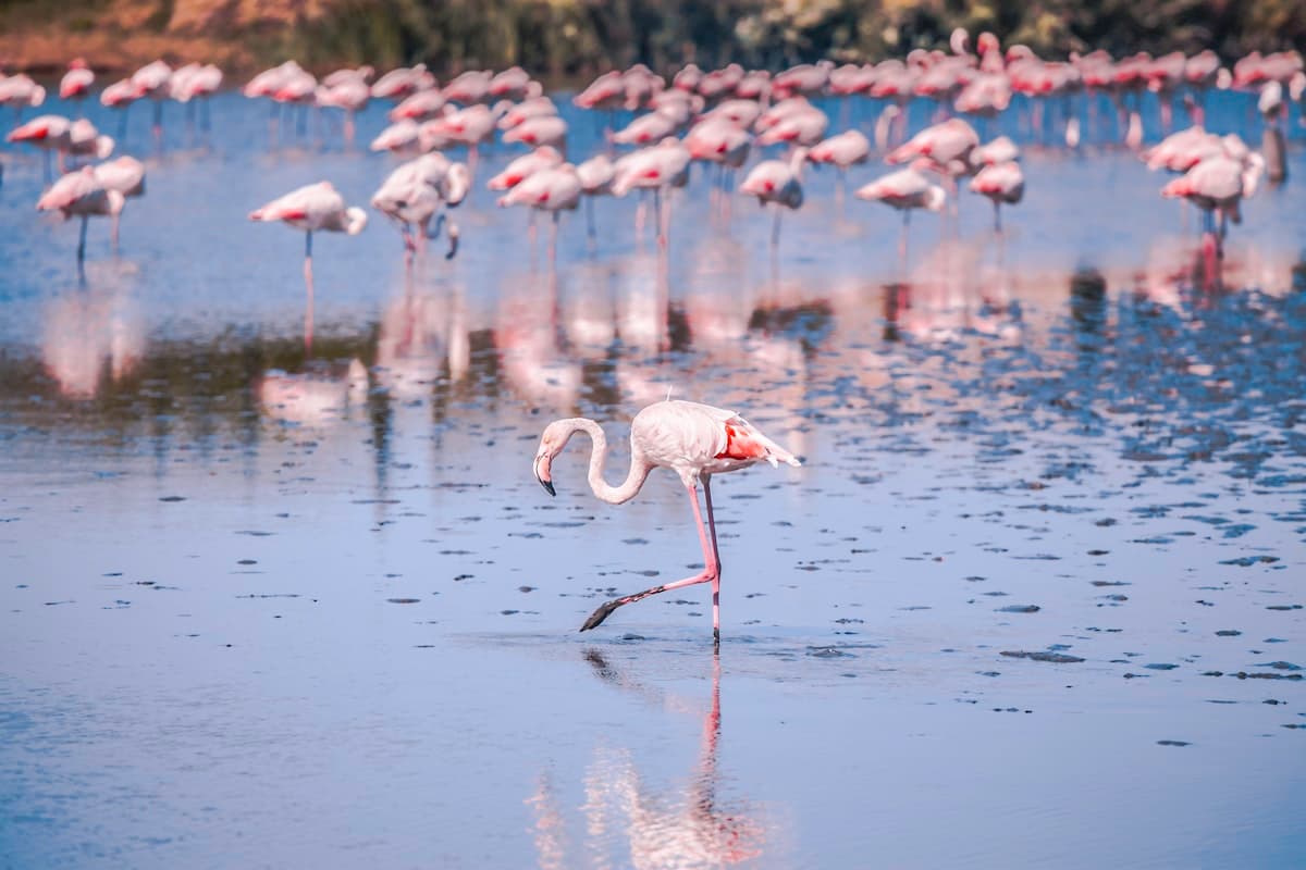
- Wildlife: pink flamingos (between 10,000 and 20,000 individuals depending on the year), herons, egrets, avocets, white storks, Camargue horses and black bulls roaming semi-wild
- Light: in the late afternoon, the lagoon waters turn pink, orange and purple — a photographer's dream
- Silence: away from the tourist roads, trails through the heart of the Camargue are surprisingly peaceful, even in season
- Wild beaches: some routes end at kilometres of pristine beach, accessible only on foot or horseback
On the gear side, Camargue trails are generally flat and well-marked, but the heat, wind and mosquitoes can turn a pleasant outing into an ordeal. Bring a high-factor sun cream, a large insulated water bottle, and insect repellent. For birdwatching, a pair of lightweight binoculars makes all the difference.
The 8 must-do hikes in the Camargue
1. Bird Hides Loop — Marais du Pont de Gau
Distance: 17.7 km | Elevation: +8 m | Level: Easy | Duration: 4h30
The Parc Ornithologique du Pont de Gau, two kilometres from Saintes-Maries-de-la-Mer, is the best entry point for observing flamingos in their natural habitat. This loop traces the marshes bordering the park, offering spectacular views over flamingo colonies — particularly active in spring when the birds are nesting.
The trail follows earthen levees between the lagoons, with purpose-built observation hides at regular intervals. Early in the morning, when the raking light catches the still water, groups of pink flamingos look almost unreal — like a dream image hovering over the surface.
The highlight: at sunrise, the pink reflections of the flamingos in calm lagoon water make for one of the most beautiful natural spectacles in Provence.
2. Camargue Hiking Loop — Saintes-Maries-de-la-Mer
Distance: 15.9 km | Elevation: +7 m | Level: Easy | Duration: 4h
This loop sets off from Saintes-Maries-de-la-Mer, the capital of the Camargue and a place of world-famous gypsy pilgrimage. The trail explores the territory between lagoons and sea, crossing sansouïres carpeted with glasswort and sea purslane, skirting irrigation channels (roubines) and offering views across the Grande Palun marshes.
The itinerary is accessible to all, including inexperienced walkers. The terrain is virtually flat, well waymarked, and the landscapes shift constantly — alternating between stark mineral salt flats and lush, life-filled wetlands.
The highlight: the diversity of atmospheres within just a few kilometres — from the animated village of Saintes-Maries to the absolute wildness of the interior marshes.
3. Phare de la Gacholle Loop — Long Version
Distance: 15.8 km | Elevation: +6 m | Level: Easy | Duration: 4h
The Phare de la Gacholle, built in 1882, is one of the great symbols of the Camargue. This loop reaches it via the dunes and salt flats of the Réserve Nationale de Camargue. The trail follows the digue à la mer — the road running between the Étang du Vaccarès and the Mediterranean — with open sea on one side and bird-filled lagoons on the other.
This is where the Camargue reveals its true soul: the end of the earth between two bodies of water, wind-lashed, where the vegetation hunkers down to survive the salt. The view from the lighthouse takes in sea, lagoons and the distant ridges of the Alpilles on clear days.
The highlight: the lighthouse itself, whose beam once guided ships between the Gulf of Lion and the Rhône estuary. Now automated, it stands as a solitary landmark in the Camargue immensity.
4. Wetlands Loop — Beach at Golfe de Beauduc
Distance: 15.5 km | Elevation: +5 m | Level: Easy | Duration: 4h
Beauduc is one of the Camargue's best-kept secrets. This wild beach, reachable only by dirt track or on foot, has stayed unspoiled thanks to its remoteness. This loop crosses the wetlands of the southern reserve before arriving at this corner of paradise.
The beach at Beauduc stretches for several kilometres, with no infrastructure whatsoever, crystal-clear water in summer and an overwhelming sense of space at any time of year. It's also a well-known kitesurfing spot, but walkers can easily find a quiet stretch.
The highlight: the gradual approach to the beach after threading through the wetlands — the jarring contrast between the world of salt and low scrub and the sudden opening onto the Mediterranean.
5. Étang du Fangassier Loop
Distance: 12.5 km | Elevation: +6 m | Level: Easy | Duration: 3h30
The Étang du Fangassier is the main nesting site for flamingos in France. Each spring, thousands of breeding pairs build their cone-shaped mud nests here, lay their pink eggs and raise their grey chicks. It is an ornithological spectacle of rare intensity.
This loop circles the lagoon at a respectful distance from the colony. Binoculars are essential for observing the details of flamingo social behaviour — their courtship displays, neighbourly squabbles and collective movements that seem almost choreographed.
The highlight: watching the flamingos during the nesting season (April–June), when thousands of birds fill the lagoon — a sight unique in western Europe.
6. Flamingos Loop — Statue of Vovo the Bull
Distance: 11.6 km | Elevation: +6 m | Level: Easy | Duration: 3h
This loop from Saintes-Maries blends flamingo watching with Camargue culture, embodied here by Vovo the Bull — a legendary local animal whose statue stands proudly on the lagoon shore. The route traces canals and marshes alive with ducks, herons and, of course, flamingos.
It makes an excellent introduction to the Camargue for families or walkers with limited time. The trail is accessible, well-marked and offers regular birdwatching vantage points. Children love ticking off species against a checklist as they walk.
The highlight: the quintessential Camargue atmosphere — white horses grazing freely, black bulls in the distance and pink flamingos lifting off into the sunset sky.
7. Notre-Dame-de-la-Mer Loop — West Beach of Sainte-Marie
Distance: 11.1 km | Elevation: +8 m | Level: Easy | Duration: 3h
Saintes-Maries-de-la-Mer takes its name from the Marys — Mary Magdalene, Mary of Clopas and Mary Salome — who legend says landed here after fleeing Palestine. The 12th-century fortified church dedicated to them is the heart of the town and the starting point for this loop.
The trail heads west along the beach before looping back through the inland marshes. You often encounter manadiers (Camargue cowboys) driving their herds of bulls and horses — a scene barely changed across the centuries. The return leg, along the lagoon edge, offers fine views back to the medieval church against the sky.
The highlight: the west beach, quieter than the main beach, stretching for kilometres of wind-swept golden sand with views to the offshore Camargue islands.
8. Phare de la Gacholle Loop — Short Version
Distance: 9.7 km | Elevation: +1 m | Level: Very easy | Duration: 2h30
For those wanting to experience wild Camargue without venturing too far, this shorter version of the Gacholle Lighthouse loop is ideal. It follows the same spectacular scenery along the sea wall, with lagoons on one side and the Mediterranean on the other — but in a format suited to families with young children or walkers looking for an easy outing.
The trail is entirely flat with no technical difficulty whatsoever. The main challenge is the wind, which can blow hard across the exposed sea wall — bring a light windproof layer even on sunny days.
The highlight: total accessibility that allows everyone — children, seniors, beginners — to experience the unique sensation of wild Camargue.
Practical tips for hiking the Camargue
The right kit for this terrain
The Camargue is flat, but its particular climatic conditions call for some preparation:
- Lightweight, breathable footwear rather than heavy mountain boots — the ground is soft but sometimes wet
- High-SPF sunscreen — the open spaces offer little shade and the sun is intense
- A wide-brimmed hat and sunglasses — essential on the sea wall
- Effective insect repellent — Camargue mosquitoes have a fierce reputation, especially at dusk
- Binoculars — bird observation is the heart of the Camargue experience
Wildlife to watch for
The Camargue is a birdwatching paradise recognised across Europe. Here are the most iconic species to look out for:
- Greater flamingo (Phoenicopterus roseus): impossible to miss, especially around the Étang du Vaccarès and Fangassier
- Cattle egret: often perched on the backs of horses and bulls
- Little egret: a small white heron, very common along the canals
- Avocet: recognisable by its upward-curved bill
- White stork: present in spring during migration
- Camargue horse: the local breed, grey-white, living semi-wild in the marshes
Getting your bearings in the reserve
The heart of the Réserve Nationale de Camargue (around the Étang du Vaccarès) is regulated. Some trails and levees are freely accessible; others require a permit. The Centre d'Information de Ginès, at the entrance to the reserve on the D570, provides all practical information and trail maps.
Find all the routes on OpenRando
You'll find all these hikes and many more on the OpenRando Camargue map, with downloadable GPX tracks and full details for each itinerary. Filter by distance or duration to find the walk that fits your day.
Hiking the Camargue through the seasons
Spring (March–May): the great season. Flamingos are nesting, glasswort flowers give the ground a pinkish hue, migratory birds are passing through. Weather is mild, light is superb.
Summer (June–August): intense heat (35–40°C possible) and mosquitoes in full swing. Outings should start early or finish late. Avoid the midday hours entirely.
Autumn (September–October): less crowded, golden light, pleasant temperatures. Some flamingos begin departing for their wintering grounds in Spain or North Africa.
Winter (November–February): the winter Camargue has a particular spell. The mistral can blow hard, but the clear air opens up exceptional views. It is the best period to observe the waterfowl (ducks, geese) that winter in the delta.
Hiking in the Camargue means accepting a slower pace — observing rather than conquering, letting the shifting light and bird behaviour guide you rather than a stopwatch or an elevation profile. It is an experience of stripping back and of wonder, one that leaves a lasting mark on the memory of anyone who walks these paths.
Camargue trails are not climbed — they are glided through, between sky and water, between salt and wind. And that is precisely why they are worth every step.
As an Amazon Associate, we earn from qualifying purchases. Links marked with an external icon are affiliate links.