Itinerary: the GR51 Balcons de la Méditerranée in 3 days
It hugs the limestone cliffs of the Calanques, crosses the thousand-year-old forest of the Sainte-Baume, and winds through the hills immortalised by Marcel Pagnol: the GR®51 Balcons de la Méditerranée is one of the most spectacular long-distance trails in the south of France. Stretching 540 kilometres from Menton to La Madrague near Marseille, it can be tackled section by section at your own pace. This guide presents one of its finest stretches: three days between Marseille, the Calanques of Cassis, and the Sainte-Baume massif.
Approximately 55 km in total, 2,100 m of cumulative elevation gain, two nights in a gîte or refuge — a distillation of Provence that will take your breath away, accessible to regular hikers in good shape.
The GR51 Balcons de la Méditerranée: overview
The GR®51 is the great coastal and hinterland trail that links the French-Italian Riviera to the waters of the Marseille bay. It follows the "balconies" — the ridges and plateaux that overlook the Mediterranean from 200 to 800 metres above sea level — offering continuous panoramas over a deep blue sea.
Unlike the GR®98, which hugs the shoreline, the GR51 seeks out ridgelines, forests and hilltop villages. It is a high-quality trail: well signposted in red and white, with frequent markers, but sometimes technical terrain — especially through the Calanques and along the Sainte-Baume ridges.
This Marseille section alone encompasses three exceptional natural heritage sites:
- The Calanques National Park — one of the few peri-urban national parks in Europe, with its limestone fjords plunging into crystal-clear water.
- La Sainte-Baume — a mythical massif sheltering a two-thousand-year-old sanctuary cave, a forest of beech and lime trees unique in Provence, and 360° views.
- The Garlaban massif — Pagnol's hills, silent and scented with thyme, the wild playground so vividly described in My Father's Glory and My Mother's Castle.
Preparation and logistics
Required level
This itinerary suits regular hikers in good physical condition. The stages range from 17 to 20 km, with elevation gains of 400 to 800 m. The Calanques trails include some rocky passages that require care on dry ground. Avoid the ridges of the Sainte-Baume in strong Mistral conditions.
When to go?
Spring (March–June) and autumn (September–November) are the best seasons. In summer, the Calanques are subject to fire-risk access restrictions (typically June to September — always check before you go on the Préfecture 13 website). July–August temperatures also make hiking very demanding after 10 a.m.
How to get there and back?
- Departure: Marseille is served by TGV from across France. The Stage 1 trailhead is at the Luminy campus, reachable by bus 21 from Rond-Point du Prado.
- Return: Aubagne has a SNCF station (Marseille–Toulon line), with trains every 20 minutes to Saint-Charles. Journey time: 15 minutes.
- By car: park at Aubagne station (paid parking) and get to Marseille-Luminy by public transport (bus + metro, 45 min).
Accommodation along the route
- Night 1 in Cassis: plenty of options from town-centre hotels to youth hostels. Book ahead on weekends and in high season.
- Night 2 at Plan-d'Aups-Sainte-Baume: the Hôtellerie de la Sainte-Baume (run by Dominican monks) is the classic choice; the Nans-les-Pins gîte (5 km off the GR) is a good alternative.
Stage 1 — Marseille Luminy → Cassis via the Calanques
Distance: 19.5 km | Ascent: 487 m | Duration: 6h–7h
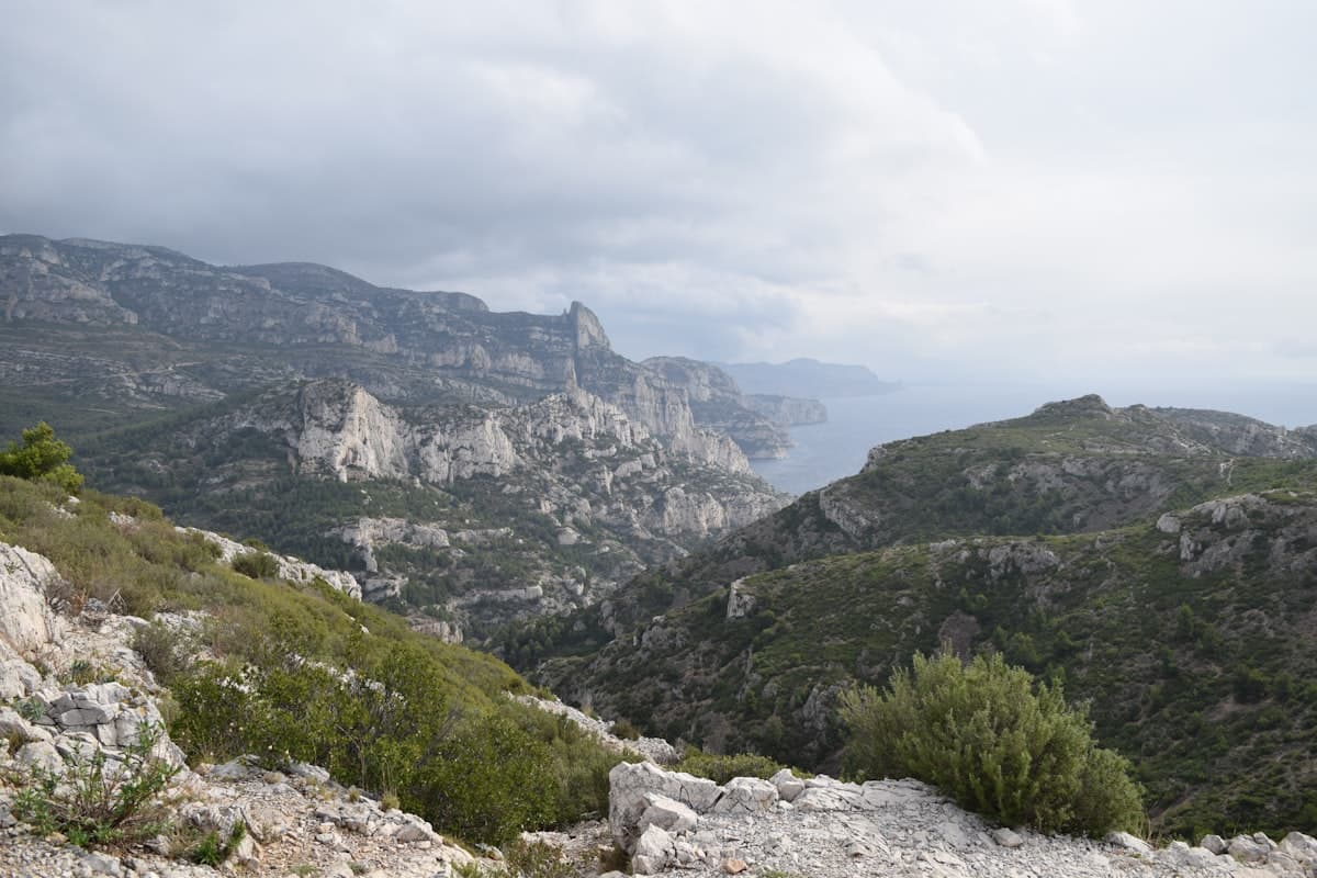
The first day is a Mediterranean baptism by fire. From the Luminy university campus on the edge of the Calanques National Park, the GR51 immediately dives into a labyrinth of limestone ridges and hidden creeks.
The trail descends towards the Calanque d'En-Vau, the absolute jewel of the Marseille coastline: a fracture in the white rock where the water shifts from jade green to deep blue. On a weekday out of season, you can swim there in near-total solitude. The path then climbs back onto the ridges above the Calanque de Port-Pin, less crowded and framed by Aleppo pines.
The route then traces the Marseilleveyre massif with successive views of the Riou archipelago and its uninhabited islands, before descending into Cassis — one of the prettiest small coastal towns in France, with its colourful harbour, blue fishermen's huts and the Cap Canaille cliffs looming 400 m overhead.
Arrive in Cassis by mid-afternoon with time for a swim or a tasting of Cassis AOC white wine before dinner.
View OpenRando route — Calanques de Cassis (ridge trail) — 19.5 km, 487 m ascent
See also: Calanque de Port Miou – Port-Pin loop — 19.4 km, 754 m ascent
Stage 2 — Cassis → Plan-d'Aups-Sainte-Baume
Distance: 18.2 km | Ascent: 731 m | Duration: 5h30–6h30
The second day delivers a striking contrast: from the glittering Mediterranean to the cool depths of the largest broadleaf forest in Provence. The GR51 leaves Cassis heading north towards the Sainte-Baume massif, climbing slopes scented with thyme and rosemary.
Halfway up, arriving at the Sainte-Baume forest is a sensory shock. While the surrounding Provençal hills are dry and scrubby, here grow beech trees, lime trees, yew and wild orchids. This ancient forest, protected for centuries by the monks who venerated Mary Magdalene within its cave, has survived the ages thanks to a unique microclimate.
The ascent to the Chapelle du Saint-Pilon (994 m) is the day's highlight: the panorama spans 360° from the coast between Marseille and Toulon, across the Alpilles and Luberon ranges, and on a clear day all the way to the Alps. The chapel has been a pilgrimage destination for centuries — tradition holds that Mary Magdalene spent her last years here.
The descent to Plan-d'Aups-Sainte-Baume crosses green meadows where horses graze freely.
View OpenRando route — Côte d'Azur viewpoint / Grotte Sainte-Marie-Madeleine loop — 18.4 km, 531 m ascent
See also: Chapelle du Saint-Pilon from Riboux — 18.2 km, 586 m ascent
Stage 3 — Plan-d'Aups → Garlaban massif → Aubagne
Distance: 18.1 km | Ascent: 801 m | Duration: 6h–7h
The third and final stage crosses the Garlaban massif — the hills immortalised by Marcel Pagnol in My Father's Glory and My Mother's Castle. These jagged white limestone ridges, separated by secret valleys of olive groves and kermes oaks, are the very essence of wild Provence.
The GR51 climbs first to the Garlaban summit (714 m), a craggy pinnacle visible from across the region and a true emblem of Pagnol's childhood. The trail then follows a series of windswept ridges before dropping to the Camp Major plateau — the high ground where Pagnol set his boyhood hunting adventures.
The final hour descends gradually into Aubagne, Marcel Pagnol's birthplace and the capital of Provençal pottery. The terracotta rooftops of the old town come into view long before you reach them — a well-earned arrival at the heart of Provençal history.
View OpenRando route — Le Garlaban – Grotte du Grosibou loop (Camp Major) — 18.1 km, 801 m ascent
Explore more hikes across these massifs on our /explore page.
Recommended gear
For a 3-day trek through Mediterranean terrain, your kit should balance lightness with resilience against heat and the sometimes abrasive limestone surface:
- Footwear: lightweight trail shoes or low-cut hiking boots work well on this terrain. Higher ankle support is more comfortable on the Calanques scree.
- Backpack: a 28–35 litre pack is enough for 3 days in a gîte, with a change of clothes, first-aid kit and water.
- Hydration: critical on this route — in summer, plan 2–3 litres per stage. A filter bottle lets you top up from village fountains and springs along the way.
- Sun protection: the white limestone reflects light intensely. A cap, polarised UV400 sunglasses and SPF50 sunscreen are essential year-round on the exposed ridges.
- Trekking poles: helpful but not essential. Recommended for the steep Sainte-Baume descents if carrying a heavy pack.
Variants and extensions
This 3-day stretch is just an introduction to the GR51. Here are some extensions:
- Heading east: from Cassis, the GR51 continues to La Ciotat, Bandol and Toulon. The Cassis–La Ciotat section follows the Cap Canaille cliffs — the highest sea cliffs in continental Europe at 394 m.
- The Balcons de l'Hérault: for a different GR51 section further west, the stretch around Puechabon and the Hérault gorges offers a greener, less crowded alternative with equally dramatic scenery.
View OpenRando route — Les Balcons de l'Hérault (Puechabon) — 18.3 km, 317 m ascent
More itinerary articles you might enjoy:
Practical information
Waymarking and maps
The GR51 is marked with red and white stripes (official GR marking from the FFRandonnée). Waymarking is consistent and well-maintained along this section. Download GPX tracks from OpenRando before you leave to navigate offline.
Estimated budget (per person)
| Item | Estimate |
|---|---|
| 2 nights in gîte / hotel | €80–140 |
| Meals and food supplies | €50–80 |
| Transport (return journey) | €15–30 |
| Estimated total | €145–250 |
Resupply points
- Cassis: supermarkets, bakeries, restaurants — everything you need.
- Plan-d'Aups-Sainte-Baume: village shop and meals at the Dominican Hôtellerie.
- Aubagne: town-centre shops, railway station 10 minutes on foot.
Before you leave, check OpenRando to explore day-hike options in each of the massifs covered by this GR51 section.
As an Amazon Associate, we earn from qualifying purchases. Links marked with an external icon are affiliate links.